Pages

Saturday 26 October 2013

over the rainbows


Landscapes nature earth machu picchu wallpaper


sumber dari: hqdesktop.net

the official entrance


sumber dari: katejohns.blogspot.com

Tourists fly out


Japanese tourists wait in line to be evacuated by helicopter from the Machu Picchu Pueblo archeological site in Cuzco, Peru on January 28, 2010.


sumber dari: thehindu.com

IES Abroad Santiago students at Machu Picchu


sumber dari: studyabroadphoto.com

Machu Picchu preservation


The president of the Association of Cusco Tour Agencies says he’s concerned that poor management and overcrowding at Machu Picchu is taking an undue toll on the iconic Inca citadel, and he blames the Ministry of Culture.

Enrique Velarde told Peru’s tourism trade publication T News that the Culture Ministry is taking too long to update the Machu Picchu Master Plan. He said the ministry is dragging its feet on improving Machu Picchu’s tourist infrastructure and implementing new rules for visitors aimed at preserving the World Heritage site.
“It seems like they want it all to collapse,” Velarde was quoted saying.

The number of visitors to Machu Picchu surpassed one million tourists for the first time ever in 2012, according to totals published by the Ministry of Foreign Commerce and Tourism (MINCETUR).
The statistics show that during all but three months of  last year, the average number of visitors far exceeded the daily limit of 2,500 agreed to by Peru and UNESCO. Crowds swelled to well over 3,000 people per day during the months of April and July through November.

Average number of visitors to Machu Picchu far exceeded the daily limit of 2,500 agreed to by Peru and UNESCO in all but three months of the year in 2012.
For years, Peru’s tourism sector has pushed for a re-evaluation of that 2,500 visitor limit at Machu Picchu, arguing that carrying capacity could be doubled or even tripled, but only if steps are taken to thin out the concentration of people trampling through at any one time. One measure would be establishing predetermined routes through the ruins to control foot traffic. Visitors would enter in shifts spaced out across the day. Another would be to create a new entrance, and a separate exit point.


sumber dari: fertur-travel.com

Machu Picchu (Historia para niños)


sumber dari: historiadelascivilizaciones.blogspot.com

Inca Trail Marathon


The second annual 26.2 Mile Inca Trail Marathon from Erik’s Adventures takes runners through the Andes Mountains of Peru to Machu Picchu.


The Official 26.2 Mile Inca Trail Marathon and Mini Marathon takes running travel to a whole new level — literally. The second annual edition of the mountain-high race takes off on August 15, 2013 as part of a nine-day Peruvian adventure organized by Erik’s Adventures, an adventure travel company run by avid marathoners and personal friends of mine, Erik and Myra Rasmussen.

The race traverses the footpath the ancient Incas used to commute between Cusco, Peru and the world famous citadel of Machu Picchu. The professionally measured 26.2-mile course reaches an elevation of 13,800 feet and usually takes the typical hiker three days to complete.

Last year’s men’s winner, Ryan Maxwell, finished in 7:44:05, and women’s winner, Megan Murray, finished in 9:57:59. Runners have just 12 hours to complete the course and could face temperature swings from as low as 32 degrees to as high as 80 degrees. But the payoff is worth it: a photo finish in front of Machu Picchu.

“We are an organized race,” said Myra Rasmussen. “We have aid stations, we have porters along the way in case anyone gets lost and we have bibs so that we can identify our runners at all the checkpoints. We try to make this as seamless as possible.”

Rasmussen and her husband Erik are no strangers to Peru. Both are Spanish-speakers with deep ties to the country. Myra’s father hails from Peru and she grew up visiting family there often. And Erik, the founder of Erik’s Adventures, has been leading hikes on the Inca Trail since 2006. They’re both competitive ultra runners and marathoners with Boston Marathon qualifying times.


sumber dari: communities.washingtontimes.com

this moments........


sumber dari: maxinelsalvador.blogspot.com

Two Main Geologic Faults Associated with Machu Picchu


sumber dari: waterhistory.org

Make My Day


Machu Picchu


When you're on the side of a mountain in the middle of a range chock full of them, dusk turns to darkness in an instant. We were on hour six of our four hour hike, our large group of 25 people, was now two or three smaller groups, walking the same treacherous trail. I remember having the thought or feeling of relief when the sun started disappearing. I mean, there was no way our tour guide would keep us wandering through the Andes after dark, right?

My chair was part of the lead group, my seatbelt fastened and a bandanna tied tightly around my forehead to keep my neck supported. Then there were the four grown men -- two in the front and two in the back -- lifting, pushing and even sometimes pulling my chair up and down the smallest of paths. Leading the way in our group was Kyle, a brave, unbelievably determined individual.

Kyle was not only leading our group, but the entire movement, and he was doing so with an extraordinary amount of responsibility on his back. Literally. He had Steve and Michel's son, Rivers, strapped to his back in a very well-designed and durable hiking/kid-carrying backpack. Not to mention, he was holding the one flashlight our group had packed for this four-hour day hike. I still, to this day, cannot imagine the amount of pressure he felt with every single step.

I remember all of us, at one time or another, cursing our guide, the terrain, our shoes and anything else that seemed to be slowing us down. With the cameras following us, we truly felt like we were on Survivor.
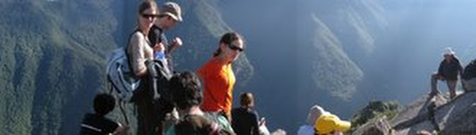
Our guide told us that once we got to the Sun Gate, the hike would get much easier and the view would be worth the work. The funny thing about the Sun Gate is that if you arrive after dark, that view is far less impressive. Shocking, I know. And while it was definitely a moral victory at that point in our journey, it would ultimately be a very short-lived celebration. Yes, we could see lights in the distance that were said to be our hotel, but the vision of Sound of Music, like rolling grassy hills our guys had promised, were instead more treacherous, twisting trails.

Once we were all used to the dark, there was actually a sense of calm. I imagine an aerial shot of our groups walking along using iPhones as flashlights and yelling out, "Five steps down, eight steps up," like we were some type of tactical force would have been quite impressive. Hell, it was impressive, I was there.
We reached a relatively flat stretch, and by "flat," I mean no sudden inclines or declines, that was far too rocky to ride in the chair because of the constant jarring of my head and neck. I was like a human bobblehead. So I decided to walk. My feet felt foreign and my legs felt like Jell-O, but it was easier -- or at least less painful -- than sitting in that damn chair.

The two men who were responsible for lifting my chair (and my life) were now holding my arms as I threw one foot in front of the other. I will forever be in debt to those two guys. One, a salt-and-peppered, New York City executive built like a yoga instructor, and the other, Steve's caregiver who could easily fill the role of Thor, literally carried me up and down Machu Picchu for 11 hours.

I know I have ALS. And I know that this vicious disease tries to break my body every day. So to try and explain or articulate the way it felt to walk across the last mile marker, then fall into the arms of a loved one and have a beer with a group like Team Gleason moments later... is beyond words. Beyond expectations. And beyond any feeling I can ever imagine having felt. It was, genuinely, a life-changing experience.


sumber dari: huffingtonpost.com
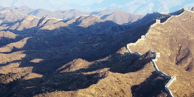
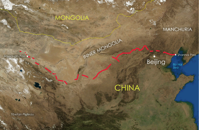
MACHU PICCHU AND LAKE TITICACA ON A BUDGET


sumber dari: taratours.com

An absolutely magical experience


Machu Picchu, Peru bw


sumber dari: land8.com

rediscovered the remote Inca site of Machu Picchu


Image © Peabody Museum of Natural History, Yale University; Used with permission


Hiram Bingham III (1875-1956) was the American professor and explorer who rediscovered the remote Inca site of Machu Picchu with the Yale Peruvian Expedition of 1911.


sumber dari: arthistory.about.com

The Most Expensive Way


Getting to Machu Picchu really is half the fun. Although the site isn't nearly as difficult to reach as it was in 1911 when historian Hiram Bingham (pictured above in a historical photograph) brought the ruins to the attention of the world, it's still no walk in the park to get there. For starters, no roads lead directly from main points of entry – Lima and Cusco – to Machu Picchu. Some choose to walk a four-day trek (or portion of it) on the Inca Trail, while others reach the base by chugging along on trains. But did you know it's possible to get to Machu Picchu in style in a wood-paneled train car with its own private balcony? Well, it is.


The "Presidential Service" by Inca Rail is by far the most luxurious way to get to Aguas Calientes, the town below Machu Picchu. If you order the service, the train operator actually attaches a private carriage to the train that includes its own bar, bathroom, panoramic windows, seating area and a balcony. As you'll see in the images below, there are also plenty of window shades so that rock stars, dignitaries and others who can afford the ride can do so without any interference. The $10,000 price tag comes with an open bar, hors d'oeuvres and tea service, plus huge bragging rights and lots of stares from passersby. Its maximum capacity is eight people, and it must be booked at least 30 days in advance.

Do you think the train ride is worth the price? And in your opinion, do you think it would add to or take away from the Machu Picchu experience?


sumber dari: gadling.com

MACHU PICCHU & AMAZON CRUISE


sumber dari: taratours.com

Top 10 Latin American Getaways


Located on the western part of South America, near Ecuador, Bolivia, and Chile, there are so many things to indulge in in this country. One of the best ways to experience it all? Making your trek through the country. The most popular route is the Inca Trail to Machu Picchu, while other routes include Cordillera Blanca, and Colca Canyon, among others. Peru has an amazing wildlife in its Amazon basin, and it also has vast deserts, giant sand dunes, and ancient ruins. (And let’s not forget the breathtaking snow-capped mountains in the Andes!) The country is rich with tradition that includes festivals, dance, music and museums. Take it all in.


sumber dari: latina.com

History of Machu Picchu


History of  Machu Picchu
The Citadel of Machu Picchu is as we know today this fortress from the Inca Empire whose ruins date from the 1300 DC. However, "Old Mountain," as its translation indicates, comes from the indigenous language Quechua. This native language is still being used in some villages in the southern part of the country, where this city is well known as the greatest Machu Picchu.

The Citadel contains the remains of the ancient settlement formed by this village part of the Inca civilization, located at the east side of the valley constituted by mountain systems, Machu Picchu and Huayna Picchu, and the Central Andes in the South of the country. This geographical location on the eastern slope of the Cordillera de Vilcanota, just 80 kilometers from the city of Cuzco, still holds many of the remains and ruins built on stone that are all over the slopes of these mountain systems, presenting the different periods of the Inca civilization that left their traces and treasures at the Citadel of Machu Picchu.


sumber dari: enjoy-machu-picchu.org

relaxing.....


Photo


sumber dari: plus.google.com

Inca Trail to Machu Picchu


Map


sumber dari: news.bbc.co.uk

Thursday 24 October 2013

on the proposed Serengeti Highway


sumber dari: actionnownetwork.com

Save the Serengeti from death highway


It is inconceivable to learn of the horrible news that the Tanzanian Government is planning to build a highway through the very sensitive Serengeti National Park. How can they even think of this? The proposed highway would run right through the northern section of the park and disturb the ancient migration route of millions of wildebeests, zebras, elephants and gazelles. Tanzania has long been known as a beacon of conservation, having saved 25% of their entire land mass for conservation purposes.

 The Serengeti National Park is a World Heritage Site. A highway through the migration route would surely mean the end of one of the last great migrations left in the world. What is more mystifying is that a southern route, which would serve more people and leave the migration routes alone, has been proposed but not adopted.

According to the Frankfurt Zoological Society, long an important supporter of the Serengeti, the effect of the proposed highway on the park and to Tanzania's status would be tragic and dramatic:

The entire Serengeti will change into a completely different landscape holding only a fraction of its species and losing its world-class tourism potential and its status as the world’s most famous National Park - an immense backlash against the goodwill and conservation achievements of Tanzania.

The loss of the Great Serengeti Migration – the last of its kind in the world - would mean the end of Tanzania’s priceless natural and national heritage, the end of the Serengeti as an iconic World Heritage Site and also a significant decline in tourism in the Serengeti and in the neighbouring Masai Mara Reserve in Kenya.


sumber dari: labrishjamaica.blogspot.com

giraf Serengeti national park Wallpaper


giraf Serengeti national park Wallpaper


sumber dari: hdwpapers.com

Best way to see and experience


The most intimate encounter with with wildlife of the Serengeti and the migration will come from the exploration inside a safari jeep. If you are looking at watching the wildebeest and other animals crossing the river, then you will need to plan on having patience. The animals may graze for hours and days on end before taking the swim across the river. It may mean just sitting in your Land Rover or other safari vehicle and watching.


If you are fortunate to experience the river crossing, keep your eyes peeled to river banks and wildlife swimming because the crocodiles have been waiting and know they are coming. Witnessing a crocodile capture a wildebeest and wrestle their prize home is an exhilarating experience.


The same could be said for following the migrating animals. The lions and other predators know the season and in the hunting mode. Keep your eyes on the stragglers and loners because the predators have their eyes on those too. Witnessing a lion hunting and killing part of the migration is usually more exciting than the crocodiles making their kill. All of this usually requires lots of patience and watching.


Another serene experience is ballooning over the Serengeti. This adventure allows you to recognize the grandeur and size of both the Serengeti itself and the expanse of the migrating wildlife. The balloon will usually land somewhere with a breakfast waiting for you out in the Serengeti. Visit our Serengeti Resources page for more information and resources to help you plan your trip.


sumber dari: sevennaturalwonders.org

serengeti movie poster


sumber dari: moviepostershop.com

the Great Migration flow


sumber dari: lemalacamp.com

Serengeti national park, Tanzania Wallpaper


Serengeti national park, Tanzania Wallpaper


sumber dari: hdwpapers.com

the longest and largest over land migration


The Serengeti migration is the longest and largest over land migration in the world. The Serengeti plains account for over 18,641 square miles and the migration itself travels 500 miles on the path from Tanzania to the Masai Mara Reserve in Kenya. Approximately 80% of the Seregeti plains are protected by the Tanzanian and Kenyan governments.


The Serengeti is home to over 70 larger mammals and approximately 500 different types of birds. Probably the most impressive part of the migration is the herds of wildebeests that blanket the plains. The migration will kill off around 250,000 wildebeests each year.


sumber dari: sevennaturalwonders.org

Quick Facts


  • Migration crosses Tanzania and Kenya
  • Spans 18,641.1 square miles (30,000 sq km)
  • Longest and largest over land migration in the world
  • The name Serengeti means "endless plains"


sumber dari: sevennaturalwonders.org

the Serengeti Cheetah Project


Serengeti Cheetas


If you are thinking about a Tanzania safari, then the Serengeti is probably part of your itinerary. Cheetah are well known to migrate from the central to the southern Serengeti annually, and in order to understand more about this beautiful cat, the Serengeti Cheetah Project has been set up to identify the cheetah’s habits and movements.

If you would like to be part of this project and learn more about cheetah on your Tanzania safari, you can participate in the project by staying at a camp or lodge affiliated with it, such as Sanctuary Kusini. Guests at this camp can elect to take part in game drives with the specific aim of finding cheetah and identifying them. They can then submit their photographs to the project in order to track the history of each individual cheetah passing through this route throughout its life. Not only are guests able to learn more about the cheetah, they can also find out which cheetah they have seen and know they are helping in the conservation of this elusive cat during their Tanzania safari.


sumber dari: pommietravels.com

the Great Migration


serengeti_migration


To be precise, there isn't a beginning nor an end to the Great Migration, it's a circular, never-ending pilgrimage that starts again and again. Animals will follow the circular clockwise route year after year, back and forth from the Serengeti National Park, in northern Tanzania, to the Masai Mara National Reserve, in southern Kenya.

However, for the sake of setting a starting point, we could say that the Great Migration begins from late Januaryto mid-March that is, when things always begin: with birth. Indeed, several hundred thousand wildebeest calves are born each year during this period, though many will be shortly hunted by hyenas, jackals, and other predators. The animals set off in April, when the Southern Serengeti plains have dried up and become increasingly worn out. The herds gather and start the trek, following a North West direction, into the Western Corridor (near Lake Victoria), where they'll find fresh tall grasses. Although the herds include many different herbivores, the big numbers are made by Wildebeest, of course, Thomson's gazelle, and Zebra: respectively, 1.3 million, 360 thousand, and 191 thousand. Integration among the migration companions is highly accomplished. On the one hand, each species eats a different part of the grass sward and so do not compete. On the other, a larger number provides a greater safety for individuals, as there are more targets for predators.

Unfortunately, gazelles and zebras aren't the wildebeest's only companions. Several gangs of carnivores -most notably lions and hyenas- march along, closely following an irresistible and fairly convenient-to-catch protein source. Hunting is not strictly necessary: many animals will fall to the fatigue of the trip, making an easy lunch for the meat-eaters. 


sumber dari: mamboviewpoint.org

Tuesday 22 October 2013

missing u from mu


sumber dari: theborneopost.com

mascot for Thamrin City?


mascot for Thamrin City?


sumber dari: zarabalqis.com

Pentland Hills, Edinburgh


A lovely regional park located approximately 5 minutes from home.. After 3 years, only now, we managed to visit this beautiful park. We hope  this is not our last visit here.. ;)


sumber dari: aisyamommydaddy.wordpress.com

fountain at Victoria Square


sumber dari: erniekhairina.blogspot.com

Ladies Laksa Lunch


sumber dari: munamahdzarfadaaq.com

Dunnottar - the setting


Of late, the weather here has been outstanding, albeit a bit blustery.
Being on the cliff, with the nature's own wind machine, overlooking the sea reminded me of Cathy and Heathcliff - having that loony Kate Bush's song "Wuthering Height" playing in my head didn't help at all.


sumber dari: munamahdzarfadaaq.com

Ustaz Amin di Baitul Maqdis


Rombongan kali ini berada di Baitul Maqdis tidak lama kerana kami akan meneruskan perjalanan ke Mekah dan Madinah pula

IMG_9823

Seperti biasa, perjalanan masuk ke al-Aqsa di kawal ketat. Rombongan kali ini ramai anak muda, jadi banyak juga yang kena periksa betul-betul ketika nak masuk.

IMG_9837

Suasana di dalam batu tergantung saat ini

IMG_9872

Suasana di dalam masjid Marwani, masjid bawah tanah di al-Aqsa

IMG_9904

Santai bersama jemaah sambil berkongsi kisah dan pengalaman di al-aqsa


sumber dari: ustazamin.com

Sunday 20 October 2013

invasi tembok besar cina


invasi tembok besar cina


sumber dari: cavepucino.wordpress.com

Mengejar Matahari di Simatai


Pemandangan Tembok Besar China di Simatai, Beijing, China, beberapa waktu lalu. Tembok besar di Simatai yang dibangun pada Dinasti Ming tersebut membelah bukit gurun. Tembok raksasa di timur ini memiliki panjang total sekitar 6.700 kilometer, yang dibangun mengikuti kontur alam untuk membentengi China dari serangan musuh. Tembok besar di Simatai ini merupakan salah satu dari empat sektor tembok yang dibuka untuk wisatawan selain Bataling, Juyongguan, dan Mutianyu.


sumber dari: edukasi.kompas.com

Miliki Panjang Dua Kali Lipat dari Perkiraan


tembok china,the great wall,china


Survei arkeologi terbaru menyebutkan The Great Wall atau Tembok China ternyata memiliki panjang dua kali lipat lebih dari perkiraan sebelumnya. Survei yang dirilis oleh The State Administration of Cultural Heritage (SACH) atau Badan Administrasi Negara urusan Peninggalan Budaya China merupakan survei arkeologi pertama yang dilakukan terhadap ikon purba yang juga sebagai benteng pertahanan ini.

Survei dimulai sejak tahun 2007 dengan melakukan pemetaan terhadap setiap jejak dinding di 15 provinsi di China. Terungkap bahwa dinding Tembok China memiliki panjang 13,170.6956 mil atau 21,196.18 kilometer. Sementara studi sebelumnya yang dirilis pada tahun 2009 menunjukkan panjang tembok ini hanya 5.500 mil atau 8.850 kilometer mengular ke seluruh penjuru negeri.

Survei ini menyimpulkan jika ternyata Tembok China memiliki panjang dua kali lipat lebih dari perkiraan studi sebelumnya. Survei terbaru juga mengungkapakan terdapat sekitar 43.721 situs warisan yang teridentifikasi pada tembok raksasa ini.

Tembok China menjadi magnet bagi para wisatawan dari seluruh dunia untuk datang ke Negeri Tirai Bambu. Masyarakat China menyebut tembok ini dengan sebutan Tembok Raksasa 10.000 Li (Wànlĭ Chángchéng) dan merupakan tembok terpanjang di dunia yang dibuat oleh manusia. Tembok tersusun dari tumpuk-tumpukan batu yang kontruksinya dilakukan pada abad ke-7 sebelum Masehi.

Bangunan yang juga berfungsi sebagai benteng pertahanan ini rampung pada masa pemerintahan Kaisar Qin Shi Huang. Sejak saat itu beberapa bagian dinding mendapatkan renovasi dan sebagian besar bagunan direnovasi pada masa Dinasti Ming (1368-1644).

Saat ini, Tembok China terdaftar sebagai warisan budaya dunia yang diakui oleh UNESCO sejak tahun 1987. Saat ini sebagian besar dinding telah mengalami kerusakan berat dan runtuh akibat ulah tangan jahil para wisatawan saat mengunjugi ke tembok ini. "Penyelamatan dan pelestarian Tembok Besar China tidak boleh ditunda," tulis The State Administration of Cultural Heritage (SACH) dalam laporannya.

Kantor berita Xinhua melaporkan, pada tahun 2015, SACH berencana menyusun aturan khusus untuk melindungi Tembok China. Dengan mendirikan sistem pemantau untuk menjamin pelestarian warisan budaya secara efektif dikelola negara.


sumber dari: nationalgeographic.co.id

GWC in the map


sumber dari: forum.viva.co.id

kerusakan yang cukup parah


Crumbling Great Wall 4

Terutama di propinsi Gansu, tembok besar ini sudah mulai hancur rata padahal area yang rata itu sepanjang 25 mil. Dan tembok besar ini dulunya berdiri kokoh setinggi 20 kaki, sekarang sudah ambles hingga tersisa tidak lebih tinggi dari 7 kaki saja.


sumber dari: ashrul-yhanu.blogspot.com

Pemandangan Dramatis dari Jiankou


sumber dari: acehimage.com

salah satu bagian yang hilang


Heboh!! Penemuan Bagian Yang Hilang Dari Tembok Besar China [ www.BlogApaAja.com ]


Dengan menggunakan bantuan dari Google Earth, sebuah ekspedisi Internasional akhirnya telah berhasil menemukan dan mendokumentasikan sebuah dinding kuno yang diduga sebagai salah satu bagian yang hilang dari Tembok Besar China. Lokasi penemuan dinding ini terletak di bagian selatan perbatasan Mongolia.

Menurut penemuan yang dipublikasikan di Majalah National Geographic edisi maret yang ditulis dalam bahasa China, bahwa Tembok Besar di bangun oleh pemerintah China sebagai penghalau untuk mengusir penjajah mongol yang datang dari Bagian Utara.

Menurut William Lindesay seorang peneliti sekaligus pemimpin ekspedisi ini, tembok ini memiliki ketinggian sekitar 2,75 meter, dan dikenal dengan tembok Genghis Khan.Tapi setelah diteliti lagi oleh tim ditemukan fakta bahwa dinding itu bukanlah hasil karya dari Genghis Khan ataupun keturunanya, melainkan dinding tersebut merupakan bagian yang hilang dari Tembok Besar China.

Pada saat tim mencari petunjuk topografi melalui citra satelit Google earth tentang dinding tersebut tim menemukan bagian dari dinding yang terbuat dari bahan lumpur basah, Saxaul (Kayu dari semak-semak gurun), serta balok batu dari bebatuan vulkanik.Secara tidak sengaja tim ekspedisi juga menemukan fosil tembikar, sampah. Di sini tim peneliti tidak menemukan koin, atau senjata, di dinding ini tim juga tidak menemukan satupun bangunan menara pengawas yang berfungsi sebagai bagian pertahanan, seperti yang terdapat di tembok besar China.

Weatherford, seorang antropolog dari Minnesotta setuju dengan kesimpulan dari Lindesay, bahwa sisa-sisa dinding yang ditemukan merupakan bangunan China.


sumber dari: tulisan-cantik.blogspot.com